
Home - Departments - Offshore Wind Development
Preliminary studies carried out by NIWE across the coastline of India indicate good potential both off the Southern tip of the country and the West coast for offshore wind farm development in India. The offshore wind potential was assessed by the FOWIND (Facilitating Offshore Wind in India) consortium with NIWE as a knowledge partner. Based on a multi-criteria approach involving assessment of various parameters such as wind resource, bathymetry etc., eight zones each off the coast of Gujarat and Tamil Nadu were identified as potential offshore wind energy zones.
In consideration of the need for the holistic development of offshore wind farms in the country and in order to expedite the process, three models have been proposed and finalized. Additionally, the Potential Zones/Sub-zones have been identified and a strategy paper for offshore has been published on the website of the MNRE.
 |  |
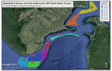
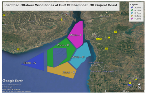
| Figure showing different zones/sub-zones in the region of Gulf of Mannar, off Tamil Nadu coast and Gulf of Khambhat, off Gujarat coast | |
Marine Spatial Planning for offshore wind farms in Tamil Nadu
Under the Indo-Danish co-operation, NIWE & DEA has jointly carried out the Marine Spatial Planning studies consisting of various significant factors such as wind speed, water depth, marine traffic, hazardous area, Environmental sensitive zones, etc.,
Following an analysis of the offshore wind potential in the Gulf of Mannar, a set of zones and subzones have been prepared for the identified prospective zones and subzones for the development of offshore wind farms in the Gulf of Mannar, which is located off the coast of Tamil Nadu. Also, the subzones are realigned considering the MNRE strategy document for the development offshore wind in Gulf of Mannar, Off TamilNadu coast. The realigned sub zones are given below under different models as stipulated in the strategy document.
 |
| Figure showing different zones/sub-zones in the region of Gulf of Mannar, off Tamil Nadu coast |
Met-Ocean Measurements (Wave, Tide, Current, Water level etc.) at Gulf of Khambat and Gulf of Mannar for Fostering the Growth of Offshore Wind in the Country
MNRE has sponsored a project to NIWE titled “Met-Ocean Measurements (Wave, Tide, Current, Water level etc.) at Gulf of Khambat and Gulf of Mannar for Fostering the Growth of Offshore Wind in the Country”.
Under this project, NIWE has initiated LiDAR based offshore measurements campaign at three locations in Tamil Nadu coast, at VOC Port (~2.5-3 km from the coast) and Udangudi (~8 km from the coast).
 |  |
| LiDAR installed at VOC_Port_1 & VOC_Port_2 | LiDAR installed at Udangudi |
ZX300M LiDAR-996 is installed at VOC PORT_1, New Harbour, Redgate, VTM Tower, Thootukudi, Tamilnadu
 |
| LiDAR installed at VOC_Port_1 |
ZX300M LiDAR-997 is installed at VOC PORT_2, Electrical Substation Terrace Near oil Jetty, Thootukudi, Tamilnadu.
 |
| LiDAR installed at VOC_Port_2 |
ZX300M LiDAR-998 is installed at UDANGUDI, Tamil Nadu
 |
| LiDAR installed at UDANGUDI |
The measurement campaign which is aimed at characterising the Gulf of Mannar wind profile will be completed in February 2025.